Notices and Highlights
Everyone
– We love our mountains!
– 22nd Snowshoe Classic canceled
– NMDOT installs new gate on Crest Highway
– New pages added for reporting trail conditions
– Forest Service announces prescribed burns
– Forest Service announces surveys on the Cibola and Gila National Forests
Members
– In Memoriam – former member Paul Torno passes
– Welcome our new members
– Volunteer opportunities
– Time to report November hours
Click on a link above to go to details below. You may need to scroll back up slightly to see the topic header. Click on the up arrow (^) at bottom right of page to return to this menu.
Supporting Sandia Ranger District Since 1997
Volunteer Opportunities
About Us
Who We Are
Our History
Trail Construction
Description
Reports and Photos
General Projects
Description
Reports and Photos
More About Us
Our Board of Directors
Our Awards and Recognition
Trail Maintenance
Description
Reports and Photos
Other Activities
Painting and Graffiti Removal
Youth Outreach
If you enjoy the outdoors and want to give something back,
join Friends of the Sandia Mountains!
Our volunteer work focuses on single-day activities in the Sandia Ranger District. If you are looking for opportunities ranging across New Mexico and often involving multi-day projects, check out our partner organization New Mexico Volunteers for the Outdoors (NMVFO) at https://nmvfo.org.
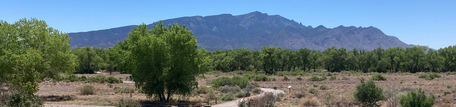
We Love Our Mountains*
Whether you are a hiker, mountain biker, cross-country skier, trail runner, or you just enjoy being in the Sandias, you know that our mountains are one of nature’s special gifts.
Have you ever wondered what you could do to help protect our mountains? Do you want to learn more about the animals and plants you find there? Do you like to meet people who share your concern for the Sandia and Manzanita Mountains?
Welcome! Please explore our website to learn more about the goals and many activities of the Friends of the Sandia Mountains (FOSM). We likely have volunteer opportunities that match your interests and abilities.
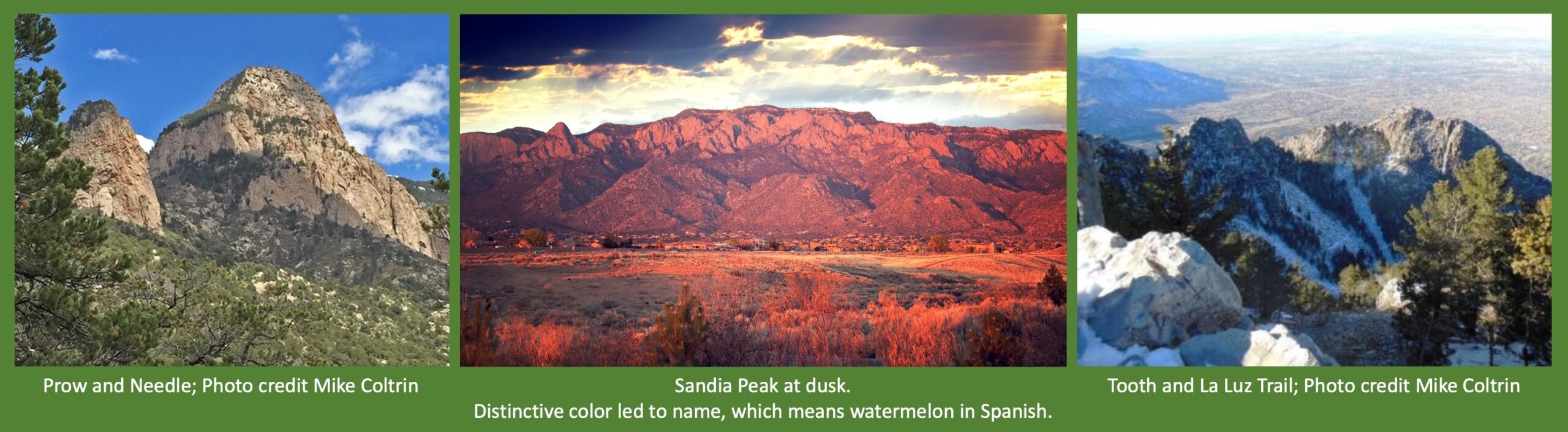
Click here to learn about the fascinating geological history of the Sandias as well as some unique features of our beloved mountains including Sandia Peak Aerial Tramway, Ten 3 restaurant, 84 medallion trees, and sadly more than a dozen aircraft crash sites.
New to Albuquerque or just new to the Sandias? Explore the many recreational opportunities our mountains offer. Please carefully read the Safety section.
Please check out our La Luz Trail webpage if you are planning to hike this iconic but sometimes dangerous trail.
An easy way to get involved is to join Cibola Trail Rangers, an email group consisting of hikers, bikers, XC skiers, horsemen, etc., who frequent the trails in the Sandia Ranger District and are interested in exchanging information on trail conditions on both an immediate and continuing basis. The group includes FOSM members trained to correct reported problems.
Please report corrective actions as well as problems so the FOSM trail maintenance crew doesn’t hike to fix a problem that no longer exists.
FOSM member Sally Lowder maintains a comprehensive database of reported trees and their disposition.
*Technically, it’s Sandia Mountain (singular), but we often use the plural because of the northern and southern peaks.
Weather and Road Conditions
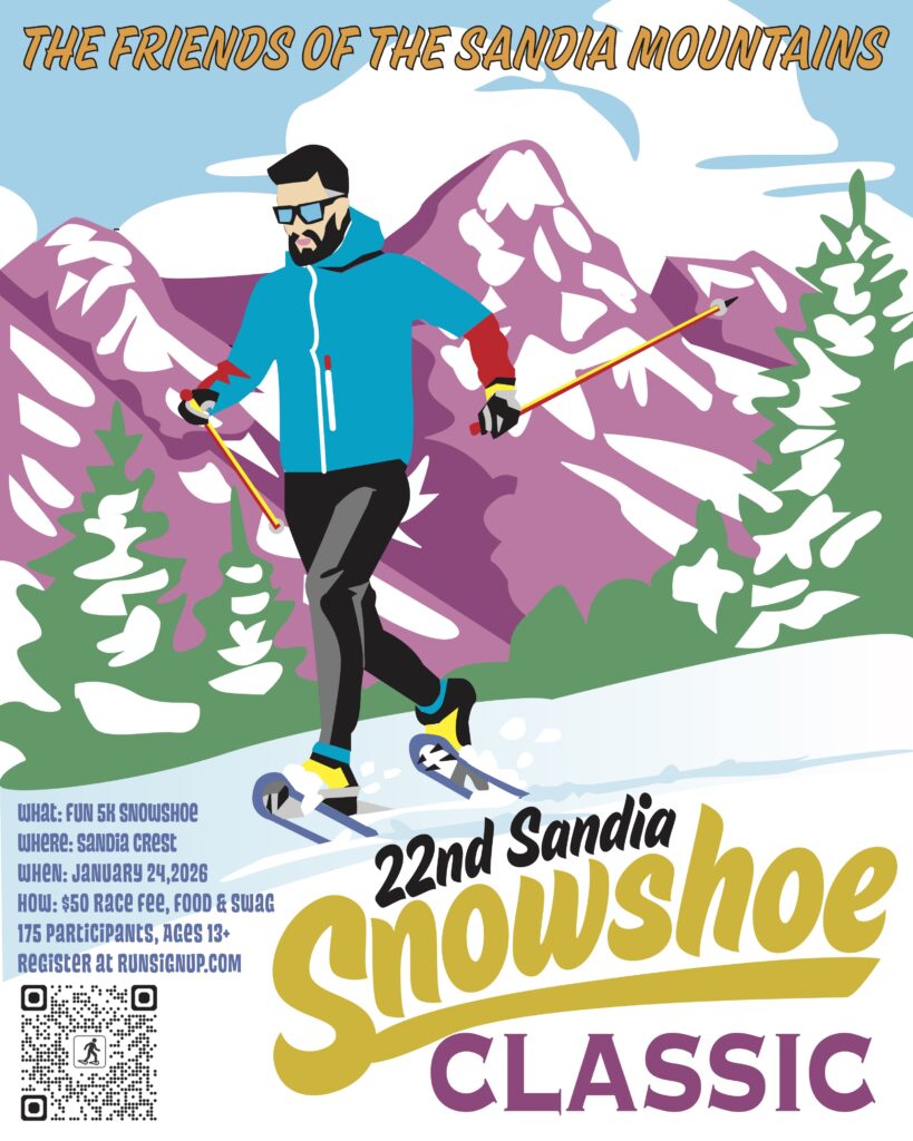
22nd Sandia Snowshoe Classic Canceled
January 22, 2026 – A significant winter storm is forecast for this weekend, and after reviewing the latest weather data, the Snowshoe Committee made the difficult decision to cancel the event, concerned about the safety of participants and volunteers. Registered participants received an email with further details and where to pick up swag. Thank you for planning to join us for this event and for your support of the Friends of the Sandia Mountains. We hope to see you next year!
Pre-event Updates
January 21, 2026 – FOSM Secretary Silke Bletzer: Weather Alert: Our snow dances may have been a bit too successful. We’re watching the winter storm warning and will provide an update on whether we can hold the race, stay tuned!
January 20, 2026 – Registration is full.
January 19, 2026 – Kerry Jones: Here’s the latest from the morning model runs… The European model (heavily weighted by OpenSnow) has trended 2X snowier, while the GFS model is drier.
January 18, 2026 – Kerry Jones: You may have noticed the official NWS forecast for Saturday now includes a low probability of snow showers for the Crest.
January 16, 2026 – Steve Roholt: The course is well covered with snow.
January 12, 2026 – Steve Roholt: The course overall is in great shape thanks to the recent snow.
January 9, 2026 – Sandia Peak Ski Area reports 12 inches of snow in past 48 hours.
December 28, 2025 – Steve Roholt: Most of the course including the section of the Service Road has good coverage. The usual spots along 130 S are getting thin/bare, but overall the course is well covered.
December 23, 2025 – Mike Madden: We have 99 registered runners as of this morning (a big number, given three weeks of record breaking mild & dry weather)!
December 15, 2025 – Mike Madden reports that 85 participants have signed up so far.
December 10, 2025 – Former Race Director Steve Roholt reports that last week’s snowstorm has left a good base on the entire course and that another snowstorm or two should provide excellent conditions for the event.
December 10, 2025 – Race Director Mike Madden reports that 80 participants have signed up so far.
Click here for more details.
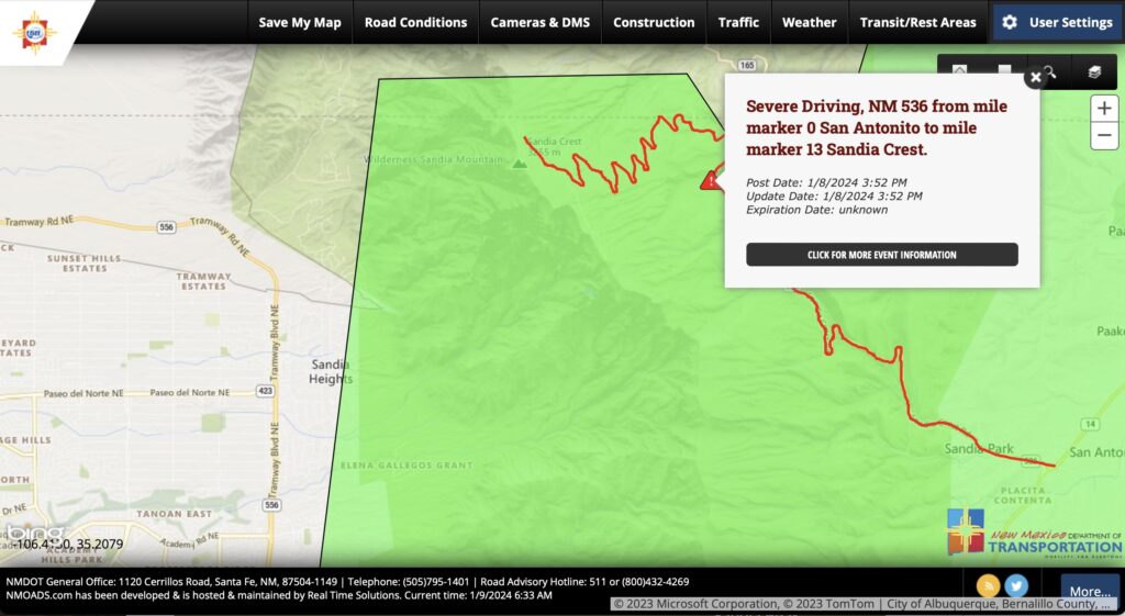
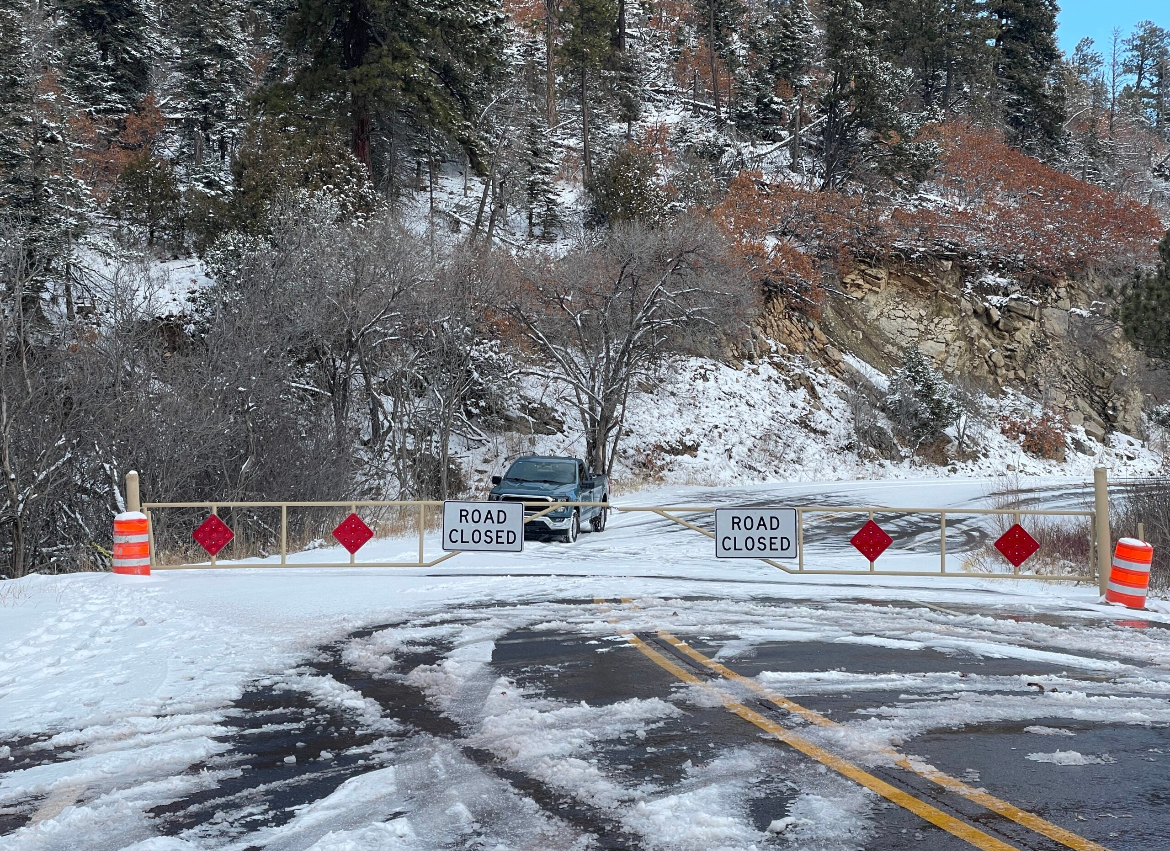
NMDOT Installs new Gate on Crest Highway
January 11, 2026 – Be aware that NMDOT has installed a new gate just past the ski area on the Crest Highway that they may close while plowing the upper mountain after a snowfall like the one a few days ago. It wouldn’t be fun to get trapped behind the gate like the owner of the vehicle in this KOB 4 photo.
New Webpages Provide Information on Trail Conditions
The best way to monitor trail conditions and contribute to their maintenance is to become a member of Cibola Trail Rangers.
A new webpage has been added in the Recreation section providing recent reports of trail conditions throughout the Sandias. This page provides excerpts from recent reports by CTR members or others about trail conditions.
A new subpage has been added below the La Luz Trail page to help inform hikers about conditions on this too-often dangerous trail. Not planning to hike La Luz but interested in conditions on top of the mountain? Reports of snow conditions near the Crest and upper Tram terminal are included as a proxy for conditions on upper La Luz.
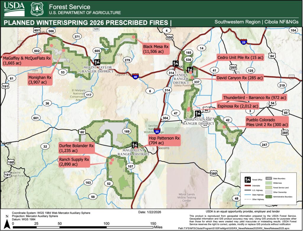
Cibola National Forest & National Grasslands Announces Prescribed Fire Projects as early as January 26
ALBUQUERQUE, NM – January 23, 2026 – The Cibola National Forest and National Grasslands are preparing to strategically implement multiple prescribed fires in the coming weeks across the forest and grasslands. See attached maps.
We estimate this work to continue through the remaining winter months into spring as weather conditions allow. Prescribed (Rx) fire helps reduce overgrown vegetation to protect local communities, infrastructure and natural resources from catastrophic wildfires.
Numerous projects are anticipated; however the exact days of ignitions will depend on wind, weather, fuel moisture conditions and required approvals.
Prescribed fires planned as early as January 26:
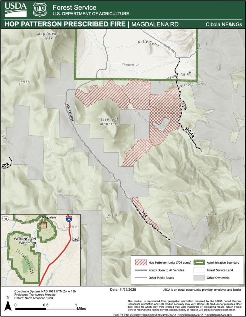
Magdalena Ranger District: Hop Patterson Prescribed Fire: 704 acres of broadcast and pile burning units located 3 miles south of Magdalena and adjacent to the communities of Hop and Patterson Canyon. Smoke may be visible from Magdalena and Alamo. See Map attached.
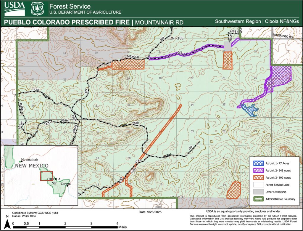
Mountainair Ranger District: Pueblo Colorado Prescribed Pile Fire Unit 2. Up to 300 acres of piles in the Coordinated Resource Management Project in the Gallinas Mountains in Torrance County, NM. Located Southeast of Willard and 15 miles Northwest of Corona, NM. Smoke may be visible from Willard, Cedarvale, Corona or within the Estancia Valley. See Map attached.
Prescribed fires planned through winter into spring include:
Magdalena Ranger District:
· Ranch Supply Rx Fire: 2,890 acres of broadcast burning in the vicinity of Old Canyon, Ranch Supply Canyons, Point of Rocks Canyon and along FSR 220. Smoke may be visible from Magdalena, Alamo, and Datil, NM.
· Durfee Bolander Rx Fire: 1,235 acres of broadcast burning in the vicinity of Bolander Canyon along both sides of FSR 220 near the junction of FSR 220 and FSR 549. Smoke may be visible from Magdalena, Alamo, and Datil, NM.
Mountainair Ranger District:
· Espinosa Prescribed Fire: 2,012 Acres of broadcast burning located on the Espinosa-Barranco Wildlife Improvement Project in the Manzano Mountains, approximately 8 miles northwest of the town of Mountainair in the southern half of the Manzano Mountains, in Torrance County, NM. Smoke may be visible from Mountainair, Punta de Agua, Manzano, and the Estancia Valley.
· Thunderbird-Barranco Prescribed Fire: 972 Acres of broadcast burning located North of the Espinosa Prescribed Fire and south of FSR 275 in the Manzano Mountains, approximately 8 miles northwest of the town of Mountainair in the southern half of the Manzano Mountains, in Torrance County, NM. Smoke may be visible from Mountainair, Punta de Agua, Manzano, and the Estancia Valley.
Sandia Ranger District:
· David Canyon Prescribed Fire: 285 acres of broadcast burning in the David Canyon area, in the Manzanita Mountains. David Canyon is located west of Hwy 337 and West of the Mars Court trailhead. Smoke may be visible from Albuquerque, Tijeras, Edgewood and Moriarty, NM.
· Cedro Unit Prescribed Pile Burn: 15 acres of piles within the Cedro unit in the Sandia Piles Rx plan. The pile burn area is in the Manzanita Mountains. Cedro is located south FSRD 462, east of HWY 337. Smoke may be visible from Albuquerque, Tijeras, Edgewood and Moriarty, NM.
ALBUQUERQUE, NM – December 10, 2025 – Cibola National Forest & National Grasslands (NF & NGs) fire crews successfully completed ignitions yesterday on the Sandia Ranger District Sulphur unit pile burning. Fire crews will continue mop up cooling ash pits and monitor until the unit is declared out. Residual smoke from the Sulphur unit pile burning operations may be visible from Albuquerque, Tijeras, Edgewood and Moriarty, NM. Map attached. For more detailed information about air quality, go to AirNow online or download the app.
Recreation access to the Sulphur area may be closed for public safety while fire crews continue with monitoring the area.
Fire managers took advantage of recent precipitation, snow covered ground, cooler temperatures, and higher relative humidity recoveries that created suitable conditions for burning piled slash and woody debris from earlier forest restoration work on the Sulphur unit.
This will be the final update on the Sulphur Unit Pile burn operations unless conditions or the situation warrants additional information.
Cibola NF & NGs Fire management will look for opportunities in the coming weeks for continued prescribed fire operations of the Sandia Piles Project on the Cedro unit pending forecasted daily weather, fuel moisture conditions and required approvals.
ALBUQUERQUE, NM – December 5, 2025 – The Cibola National Forest & National Grasslands (NF & NGs) is planning prescribed fire pile burn operations on the Sandia Ranger District as early as Tuesday, December 9 pending all required approvals. We estimate this work to continue throughout the month of December as weather conditions allow.
Fire managers are taking advantage of recent precipitation, snow covered ground, cooler temperatures, and relative humidity recoveries that create suitable conditions for burning piled slash and woody debris from earlier forest restoration work. We use prescribed fires to help protect local communities, infrastructure and natural resources from wildfires.
Sandia Ranger District Prescribed Fire planned for:
- Cedro Unit Prescribed Pile Burn: 15 acres of piles within the Cedro unit in the Sandia Piles Rx plan. The pile burn area is in the Manzanita Mountains. Cedro is located south FSR 462, east of NM-337. Smoke may be visible from Albuquerque, Tijeras, Edgewood and Moriarty, NM. Map attached.
- Sulphur Unit Prescribed Pile Burn: 18 acres of piles within the Sulphur unit in the Sandia Piles Rx plan. The pile burn area is in the Sandia east mountains, north of I-40, west of NM-14 and south of NM-536. Smoke may be visible in the surrounding areas of Albuquerque, Tijeras, Edgewood and Moriarty, NM. Map attached.
This area may be closed to the public for several days during burn operations for public safety. Watch for warning signs along roads near all prescribed fire areas before and during burns.
Residents may experience smoke during the prescribed burn. For more detailed information about air quality, go to AirNow online or download the app. Smoke is expected to lift during the day, however, cooler overnight temperatures may cause smoke to settle into low-lying areas surrounding the burn location. When driving, slow down and turn on your headlights when you encounter smoke on the road.
We will evaluate weather conditions in the hours before a burn begins. If conditions warrant, scheduled prescribed fire activities may be canceled.
Stay informed about scheduled prescribed fires through InciWeb, New Mexico Fire Information and on the Cibola NF & NGs website, Cibola Facebook and Cibola X sites. We will notify county emergency management officials when burning begins.
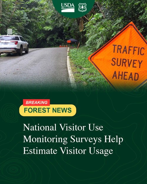
Public Surveys on the Cibola and Gila National Forests
ALBUQUERQUE, NM – September 25, 2025 – Beginning October 1, the public may encounter contract employees conducting public surveys on the Gila National Forest and Cibola National Forest & Grasslands in developed and dispersed recreation sites and along forest service roads. Surveys will be conducted through September 30, 2026.
The National Visitor Use Monitoring survey is a Forest Service program designed to estimate how many people actually recreate on national forests and grasslands, what activities they engage in while there, and how satisfied people were with their visit. These surveys are conducted on a national forest every five years.
Contract employees will be out in all types of weather conditions, wearing bright orange vests and be near a sign that reads “Traffic Survey Ahead”.
Surveys are voluntary and all responses are confidential; names are not included, and interviews last about 10 minutes.
Questions asked include where you recreated on the forest; how many people traveled with you; how long you were on the forest; what other recreation sites you visited while on the forest, and how satisfied you are with the facilities and services provided. About a third of survey participants will be asked to complete a confidential survey on recreation spending during their trip to measure the economic impact to local communities.
Information about the National Visitor Use Monitoring program can be found at https://www.fs.usda.gov/about-agency/nvum.
Member Messages
In Memoriam

Thanks, especially to Sally and Bob Lowder, for helping identify former members of Friends of the Sandia Mountains (or New Mexico Friends of the Forest) whom we’ve remembered with photos and links to their obituaries on our new webpage. Please send your suggested additions and favorite memories to
webmaster@friendsofthesandias.org for sharing on the page.
Thanks to Dan Benton for information about the recent passing of long-time FOSM member Paul Torno in Grinnell, Iowa. Paul is survived by his wife Sharon. His obituary can be found by clicking here or on the adjacent photo.
Rest in Peace, Paul.
Welcome, New Members!
Cindy Roper – January 17
Ken Sexe – January 3
Rogulja Wolf – December 14
Dennis Kellogg – December 13
William Childs – December 12
Laurie Lacey* – December 5
Aaron Brooks – October 17
William Gruner – October 13
Dana Price – October 11
Don Fisher* – October 8
Deb C. Hall – September 12
Megan Batchelor – September 1
Nelly Taveras – August 31
Christopher Cudia – August 26
Douglas Binder – August 19
Susan Morro* – August 8
Iris Meyer-Guthman – July 12
*Life sponsor
Volunteer Opportunities
Snowshoe Classic – Race Director Mike Madden sent the following message on January 24: You are receiving this email because you volunteered to work today’s race day event. As you know, this year we had to cancel due to forecasted unsafe upper Crest Road driving conditions. You are entitled to a versatile head wrap (neck gaiter).
As Race Director, I’d like to thank you for your desire to serve our greater community. We hope to see you next year!
Paint Crew Leader – Thanks, Anne Hickman for your years of faithful service as leader of the paint crew. Anne has stepped down due to other commitments. Please use the form on the referenced pages if you would be interested in assuming this leadership position.
Report Volunteer Hours
Expect a monthly call for hours going forward during Forest Service fiscal year 2026 (October-September).
*The weekly crew leaders (Bob, Sam, Laura) have already provided their crew’s hours by individual into our FY2026 FOSM hours tracker, so if you signed an attendance sheet, your hours are already covered.
*Basically, report any and all individual time spent in a FOSM activity which pertains to the District.
Additional guidelines for reporting hours can be found here.